
The other week, MH and I went to a relatively close-by park that was once the estate of the billionaire Doris Duke. Since her passing her mansion has been torn down and other buildings have been made more ecologically friendly. In fact, the whole park is a model for eco-friendliness. For instance, we went looking for a newer trail map and discovered these are not printed anymore, to save on paper. (Luckily, we had brought our old paper map.) A tram that would take people to some of the more notable landmarks on the property had been discontinued to save on fuel and pollution (and the cost of maintenance, no doubt).
 |
| Duke mansion (Margo D. Beller) |
I mention all this because one brochure that was available related to geocaching. What is that, you might ask? It is a form of treasure hunt except you use your mobile phone's GPS to locate the prizes at specific locations. According to one site I found, there are 4,422 geocaches in my area alone.
No thanks.
However, others love this stuff, not just in my area but all over the world. Since this is an activity that you do by getting off your couch, leaving your home and getting outside, preferably into nature (albeit with a phone in your face), there are some nature organizations that want to take advantage of the foot traffic and don't mind hosting some of these geocaches if it promotes their parks. Duke Farms, I now know, is one of them. At least in 2015, so was the Scherman Hoffman sanctuary of New Jersey Audubon.
Here is what I wrote about geocaching for the Scherman Hoffman blog. I took all the pictures:
 The treasure hunt has gone high-tech.
The Northern New Jersey Cachers (NNJC) held a “meet and greet” at Scherman Hoffman on May 31, a unique partnership between a group dedicated to expanding interest in using satellite technology to find caches and a sanctuary that, as its website says, is “focused on nature.”
If you see an inherent contradiction here, you’re right.
For this treasure hunt, called geocaching, you need global positioning satellite, or GPS. Ever since the Clinton administration stopped scrambling government satellite data, the use of GPS has exploded.
According to NNJC President John Neale, once GPS took off it was just about inevitable some techie wonk would make a game with it. That happened in 2000, in Oregon, when a couple of hikers found an old bucket in the woods. Instead of passing it by and forgetting about it, they put the coordinates -- good old longitude and latitude -- on a website for others to find.
From those humble beginnings the movement has grown to 220 countries, 2.5 million active caches and over 6 million geocachers worldwide, according to geocaching.com. Neale told me that in New Jersey alone there are 16,000 caches. His group has over 500 members and there are separate organizations that cover central and south Jersey.
The cache can be anything, of any size. Some are big enough to fit into ammunition boxes. Some are “nano-caches” that can be easily concealed in big cities. Griggstown Grasslands has caches concealed in the false bottoms of a few bird boxes. Typically, it’s a plastic lock box that contains a pencil and pad of paper for signing your name. The cache can be anything from a toy Jeep (many are sponsored by Chrysler dealerships - it’s good publicity) to a manhole cover. If you take the cache you must leave something of equal or greater value.

Then you log your finding in your logbook and log the experience at the geocaching.com website.
So on a lovely Saturday morning more than a dozen people chatted, ate cookies baked by one of the long-time cachers and waited for the coordinates of the 10 Scherman Hoffman caches to “go live” so the hunters could check their phones and then their GPS and start hunting.
So on a lovely Saturday morning more than a dozen people chatted, ate cookies baked by one of the long-time cachers and waited for the coordinates of the 10 Scherman Hoffman caches to “go live” so the hunters could check their phones and then their GPS and start hunting.
The event was intended to bring newbies and more experienced geocachers together. Neale said that besides being a fun activity for people of all ages there is a competitive aspect. Case in point: One older man he pointed out is ranked ninth in the world in finding geogaches. Like a lot of cachers, this man goes by an alias, IMSpider. Neale - whose own alias is Old Navy - told me IMSpider took up caching with a vengeance after his wife died years ago. Now he doesn’t even bother using the pencil when he finds the caches, he stamps his name.
Any birder who has been involved in the annual World Series of Birding or has read The Big Year or To See Every Bird on Earth knows that competitive aspect too well.
Bird watching has also become more high-tech. There are bird calls that can be stored on mobile phones for checking in the field as well as GPS, high-tech cameras and sites such as New Jersey Audubon’s eBird, which allows you to check what has been found and where, including coordinates.
We’ve come a long way from a walk in the woods.
Ironically, that’s how Neale got into geocaching. Neale loves to hike and gained a love of nature traveling with his mother when she worked at Watchung Reservation. She worked with Dorothy Smullen, now a teaching naturalist at Scherman Hoffman and the point person on the meet and greet.
Smullen said the route of the caches runs along the Dogwood (Red) trail, crosses the driveway heading toward the vernal ponds near the NJ Audubon headquarters building at 9 Hardscrabble and then along the River (Yellow) trail (see below). Each cache has letter(s) inside the box tops. When unscrambled, the letters complete a phrase that cachers can use for a discount on some merchandise in the Scherman Hoffman store. Cachers could also buy a collectible "path tag" with the NJ Audubon logo to keep as a souvenir or drop at their next cache.
 |
| The Passaic River running through the Scherman Hoffman sanctuary. |
Smullen told me the hope is the cachers discover the sanctuary, see the beauty of the place and then come back. Many of the cachers I spoke with had never been to Scherman Hoffman before, much less Bernardsville, NJ, where it’s located.
Once the cache coordinates were published, I followed one small group (2 men, 1 woman and 2 boys) to the first location. “Third boulder from the trail,” one of the men read from his phone. (Warning: In the woods, you’re likely to lose your cellphone signal.)
The boys started counting and then turning over rocks somewhat off the path. By the time they had found the cache we were joined by a larger group, who now - one by one - signed their names in the cache notebook. IMSpider used his stamp and then strode off to the next cache, up the steep hill, other cachers scrambling to keep up.
Among them were Carmine and Maria, of Jersey City and Mountainside, who have been geocaching for a year. “That guy is hardcore,” Carmine said of IMSpider with some awe as he puffed up the hill. Maria told me she’s a teacher. Trying to find some way of engaging her tech-literate students, she read about geocaching in a magazine and got them involved. That’s how she and Carmine got into it.
I think I told Carmine and Maria as much about Scherman Hoffman as they told me about their geocaching.
By this time we’d gotten to the top of the hill. But instead of veering left along the Red trail, the group continued on Patriots Path (the White trail) into the Cross Estate, which is not part of the private Scherman Hoffman but is part of the federal National Park Service's Morristown National Historical Park (Jockey Hollow).
This brings up one of the problems I find with geocaching. The official route might’ve been along the Red trail but if the GPS says the quickest way is cutting through a federal park, you follow it. Neale told me people placing caches are supposed to get permission from landowners and at least warn states and the federal government there will be caches and people looking for them. But that does not stop people from using shortcuts.
One geocacher told me he does not believe in bushwhacking and puts all his caches within five feet of a trail. He also gives clear clues on the geocaching website so people don’t harm the environment looking for the cache.
I gather he is unusual.
Just as you will see birders putting themselves and the environment in danger by bushwhacking after a bird, you will see people put caches in inappropriate places and searchers do quite a bit of harm -- despite the organization’s rules to the contrary.
It’s part of the “game’s” competitive spirit, I guess.
Scherman Hoffman Director Mike Anderson told me geocachers inundated New Jersey’s Kittatinny Valley State Park with caches. Before the state knew it, hundreds of people were overrunning the park.
That’s the main reason NJ Audubon got involved with the NNJC -- to have some sort of control and minimize that kind of damage, Anderson said. NNJC maintains the caches. NJ Audubon trail maps, program schedules and other flyers were there for the taking, to encourage NNJC members to come back again.
I’m not sure that will happen.
 |
| Leader with box turtle |
The cachers running up the hill were too busy following the leader -- IMSpider -- to stop and listen to the birds around them or even notice the beauty of the woods.
Not everyone is like this, of course. I later found a geocacher alone on the river trail - unlike others, he came from the area - who said he doesn’t like finding caches in packs because it takes the fun out of it when others find them first. However, he showed less interest in the nearby veery I pointed out than in his ringing cellphone.
As with everything else, it is too easy to forget technology is merely a tool. Too often I see people use an iPod - even in the car - to block out the world, or stare at a game on their phone to avoid eye contact on the street. And don’t get me started on drivers blindly following GPS instructions to the exclusion of sense.
I do not use GPS (MH is my GPS) and I was glad when the cachers left me alone in the woods with the birds.
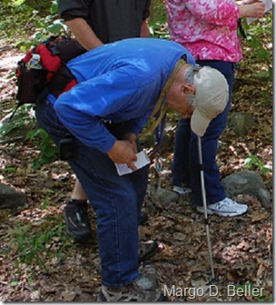
Earlier that morning I had been on the weekly bird walk with naturalist Stephanie Punnett. Our group stopped for long periods of time listening to and looking at all sorts of birds. At one point one of the younger group members looked down instead of up and found a wood turtle.
Wood turtles are threatened in NJ, and Punnett said this female was new to her because it hadn’t been marked for tracking. She put it in her bag so it could be marked and then returned to the same spot to get on with its life.
Now this was a cache worth finding.


